Phase II Testing of the Yorkshire Portion of the Holly Hill Development: Preliminary Interim Report
Principal Investigator
Marley R. Brown III
Colonial Williamsburg Foundation
Department of Archaeological Research
January 3, 1993
Re-issued
November 2003
Introduction and Background
At the request of the McCale Development Corporation, an archaeological appraisal (Phase II testing) of a site (44WB52) located on the Yorkshire portion of the pending Holly Hills housing development was conducted by the Colonial Williamsburg Foundation's Department of Archaeological Research. Previous archaeology had identified a number of sites on and near this parcel. One of these earlier investigations, the initial assessment of the Yorkshire portion of the Holly Hills tract, conducted by the Tidewater Cultural Resource Center, had uncovered a large site associated with the early colonial community known as Middle Plantation. The presence of this site necessitated a thorough Phase II evaluation of this area.
Documentary research indicate that this tract was part of Rich Neck plantation, owned from the 17th through the 19th centuries by the Ludwell family of Greensprings. The 1781 Desandrouins Map indicates this area belonged to "M. Ludwell" and shows six buildings associated with this plantation. The map shows a road leads from the present-day Jamestown Road to the main group of structures, located on a ridge overlooking College Creek. A lone structure is shown east of the main body of the plantation. To the northeast, across Jamestown Road, was Ludwell's Mill, also owned by the Ludwell family.
The project afforded an opportunity to explore aspects of the physical organization of Middle Plantation, the seventeenth-century settlement that preceded Williamsburg. Previous efforts by the Department of Archaeological Research to locate components of this scattered community have met with only mixed results. This project provided an unqualified appraisal of one component of this scattered community.
The excavation began on November 23, 1992 and took four weeks to complete. The project was carried out under the general supervision of Marley R. Brown III, the director of the Department of Archaeological Research at the Colonial Williamsburg Foundation. Staff Archaeologist David Muraca directed the field work and prepared this report. Field Technician Steve Atkins supervised a field crew made up of Ywone Edwards, Beth Anderson, and Audrey Horning-Kessler. Laboratory processing was performed by Laboratory Technician Pegeen McLaughlin-Pullins under the direction of Amy Kowalski, Laboratory Analyst. This report was illustrated by Kimberly Wagner.
Previous Archaeological Study
The most recent archaeological survey of a portion of the Holly Hills tract was prompted by discoveries made during the construction of Yorkshire Drive in 1988. With the permission of the Geddy family, who owned the property at that time, a terrace adjacent to the new road was examined. Parallel transects were established, spaced about fifty feet apart. Shovel test pits were excavated at forty foot intervals along the transects in search of sub-surface remains. A crew of two supervisors and thirteen graduate students from the William and Mary's Departments of Anthropology and History and other volunteers conducted the survey under the direction of Patricia Samford and Gregory Brown for the Tidewater Cultural Resource Center of the College of William and Mary.
The location of buildings associated with Rich Neck plantation (Site 44WB52) was identified by brick concentrations. Shovel tests were performed at ten to thirty foot intervals radially from this area in all directions. The 1988 testing revealed what may be two residential areas, one dating to the mid or late seventeenth century, and the other dating to the early to mid eighteenth century.
3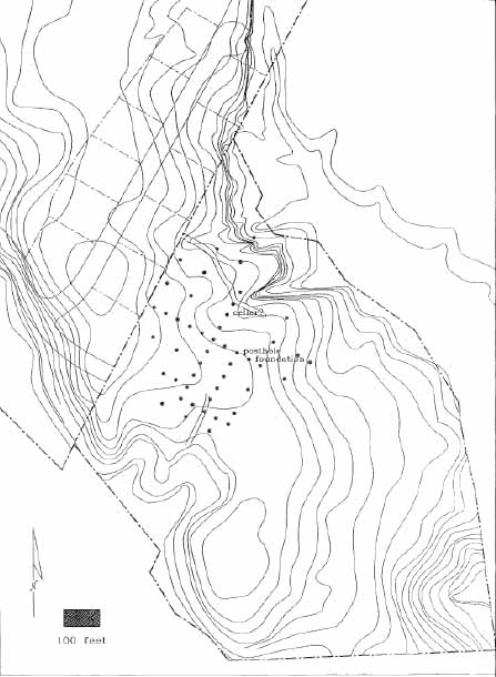 Figure 1. Test unit and feature locations.
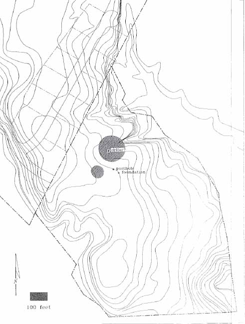 Figure 2. Location of concentrations of architectural material.
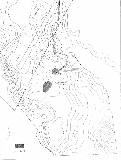 Figure 3. Location of concentration of kitchen related material.
Methods for Testing the Yorkshire Terrace
The testing strategy for this project was made up of regularly spaced, systematically placed test units. This approach was designed to insure the identification of activity areas, and designed to understand the spatial boundaries of the site. In addition an analysis of the artifacts was undertaken in order to determine the date of occupation, as well as site function.
A grid system was established to gain spatial control of the site. Test units were placed at ten and twenty meter intervals to accurately observe both horizontal and vertical aspects of the site. The unit size selected, 0.75 by 0.75 meters, allowed for retrieval of a representative artifact sample, accurate recording of stratigraphy, and the assessment of sub-surface features with only minimal disturbance to the site. An interval of 10-20 meters between units was deemed sufficient to assess the distribution of artifacts and to identify any activity areas within the site.
The coordinate system that established the location of test units was initiated from a single datum point, permanently marked by an iron reinforcing rod. Coordinates and context numbers were assigned to each unit accordingly. Measurements were made using the metric system, in keeping with the standard recording procedures of the Department of Archaeological Research.
A map showing terrain, modern disturbances, and unit locations was produced for the site. Black and white photographs along with color slides taken of select features, were used to document the testing results.
Test units were excavated by stratigraphic layers using both shovels and hand trowels. All soil was sifted through ¼-inch mesh and all artifacts were collected regardless of their age. Restricted ground visibility prevented collection of the artifacts located on the ground surface. Physical descriptions of both layers and features were recorded using the Department standardized recording form. Features were drawn in plan before being covered in plastic and back-filled. Excavation of features was restricted to poorly understood examples in hopes of identifying the function of these features. Profiles of the soil stratigraphy were completed before the holes were back-filled.
The finds were washed and inventoried using a standard descriptive typology of both historic and prehistoric materials. No minimum vessel counts were attempted due to the limited nature of the project. Faunal remains were identified as to species if possible. Artifacts in need of stabilization were sent to Colonial Williamsburg's Department of Conservation. All material, along with the documentation, were stored at the Department of Archaeological Research.
Results
A total of 47 test units were excavated on the terrace that contains 44WB52. Excavation revealed a variety of stratigraphic sequences, ranging from simple to complex. A number of different types of features were uncovered in these holes. This section will describe the physical attributes of the layers and features found, and try to establish the functions of the latter.
The most stratigraphically simple test squares contained only two cultural layers. Topsoil, a dark brown sandy loam, was found universally, and ranged in thickness from 2 to 6 cm. This layer was characterized by a light scatter of artifacts. Under the topsoil was a brown sandy loam that varied in thickness from 8 to 15 cm. This loam was formed by plowing, which folds several layers into one. Artifact densities for this layer ranged from low to high with most finds being small in size, the result of years of plowing.
Most of the units on the terrace contained an additional layer which had not been disturbed by plowing. This layer ranged in color from light brown to tannish orange, and varied in thickness from a few centimeters to over ½ meter deep. Artifacts were unevenly distributed throughout this layer.
Seven units revealed the presence of more than three layers mentioned above. The additional layers were created either in a natural manner, such as erosion, or by cultural means, such as a cellar. Some of these additional layers contained large amounts of manmade materials, others little or none. Analysis on the artifactual distribution in these additional layers is currently being undertaken.
The testing of 44WB52 revealed a large number of features. Only the features formed by cultural activity will be described in detail.
Feature 1 — Brick Foundation and Builder's Trench
A test excavation at 550N/530E contained a portion of a substantial brick foundation. Ten orange/red handmade bricks were exposed. The foundation ran roughly east-west and extended out of the unit for two meters to the east and one meter to the west. Probing suggested the wall was 2.5 bricks wide. The bricks were in laid in course, with some evidence of shell tempered mortar surviving between bricks. All the bricks were placed using the same arrangement, like headers, only laid on their narrow side. Probing revealed the presence of a second course of bricks underneath the exposed course.
The foundation was sealed by the plowzone and was contained in a builder's trench. This trench extended from 10 to 16 cm north of the bricks. The soil of the builder's trench is a dark loam with some brick and mortar fragments present. The builder's trench was not excavated.
Artifacts found in the layers above the foundation include pan roofing tiles, mortar and plaster. Domestic artifacts included a stone marble, tobacco pipes, earthenware fragments, and an animal bone. These finds suggest that the building was once a dwelling. A wooden structure was likely seated on the brick foundation, with plastered walls, and a 8 roof of earthenware tiles. While no definitive date of when the dwelling stood can be obtained by the excavation of a single test unit, artifacts recovered suggest a second half of the seventeenth century occupation. The site-wide absence of white salt-glazed stoneware, first manufactured in 1715, suggests the building was abandoned by the beginning of the eighteenth century. The dwelling is situated between Jamestown Road and College Creek, each of which would have provided access to Jamestown.
Feature 2 — Possible Cellar
The test unit located at 570N/510E contained, under the plowzone, a complex stratigraphic sequence. Under a 10 cm thick plowzone were several layers that sloped to the north. Most of these layers appeared to be deposited on purpose. Only the bottom layer had the appearance of being washed in by rain. Several layers were identified, and they ranged in thickness from 10 to 40 cm. The uppermost layers (Contexts 50, 52, and 73) were brown loams with heavy concentrations of brick and charcoal. These layers contained a variety of artifacts including ceramics, table glass, animal bones, tobacco pipes, a gun flint, and wine bottle glass. The bottom layer (Context 54) was mixed tan and orange silt, with a few brick bats and animal bones, but otherwise devoid of artifacts.
Preliminary evidence suggests this feature may have once been a cellar. Another possible function is that of a clay quarrying pit either for brick making or daub making. Similar features have been found on several other sites including Middle Plantation sites. The domestic nature of the artifacts found in these fill layers counters any conjectures about a special activity area located on this part of the site. Artifacts, including coarsewares, pipe bowls, case bottle fragments, recovered suggest the feature was filled during the second half of the seventeenth century.
Feature 3 — Clay Anomaly
Excavation of the unit located 10 meters north of the possible cellar revealed a deep stratigraphic sequence. Under plowed soil was a brown layer with heavy charcoal flecking and numerous artifacts. This thick layer (25 cm) sealed an orange clay feature and a darker brown layer. Expansion of this excavation unit to 2.25 by .75 meters exposed a large, irregular orange clay feature. The clay contained large quantities of brick bats. Coring revealed the second dark brown sandy layer sandy was just over 10 cm thick. This layer was not excavated.
An area heavily disturbed by logging activities was located just to the east of the clay feature. It is possible that this unusual stratigraphic sequence is related to this modern industrial activity. This explanation does not reconcile the large number of early colonial artifacts found near the clay feature. It is possible that this area was a colonial activity area that had been damaged by loggers.
Feature 4 — Posthole Complex
A large porthole was uncovered in the unit located just west of the brick foundation. The size of this posthole is consistent with those that make up earthfast structures. The struc- 9 ture extended out of the 75 by 75 cm unit in all four directions. The post hole was filled with an redeposited dark orange sandy clay, usually found only in holes that permeate subsoil to a significant depth.
In the eastern corner of the pothole was an irregularly shaped area of grey sandy loam, with brick and charcoal flecking. Areas like this usually signify post repair, a common phenomenon for earthfast buildings. The presence of a circular post mold located within this area supports the conclusion of structural repair.
This feature complex was not excavated and therefore cannot be dated. Artifacts found in the plowed soils above the features were the same seventeenth-century finds located over the entire site. Both clinker and coal were noted in the plowzone which suggested this area may have been used for industrial purposes.
Conclusions
The archaeological exploration of the terrace located within the Yorkshire portion of the Holly Hills development uncovered evidence of three possible structures associated with an unusually large scatter (100 × 100 meters) of artifacts that date to the second half of the seventeenth century. Within this concentration are two separate hot spots for both architectural and kitchen related artifacts. The presence of Fulham stoneware, first manufactured in the 1690s, suggests the site survived until the end of the seventeenth century. The absence of several later artifact types, including a popular stoneware that was introduced around 1715 indicates this complex was abandoned around the beginning of the eighteenth century.
Heavy concentrations of domestic and architectural artifacts indicate that a large-scale plantation once existed on this terrace. The architectural details suggest a affluence not commonly seen during the second half of the seventeenth century in Tidewater Virginia. Roofing tiles, window glass, brick foundations, flooring tiles all suggest rising social status; however, the domestic artifacts offer a different picture. The relative scarcity and commonplace nature of the domestic finds suggest a plantation of a more middling nature.
While the majority of artifacts recovered were either domestic or architectural, there was a smattering of industrial related artifacts. Several earthenware tiles spotted with dripped lead glaze were found on the site. These have been interpreted as pottery kiln furniture, and suggest that ceramics were fired on site. Traveling potters were common early in the seventeenth century, but were seen infrequently in the latter half. Coal and clinker were also found on the site.
Artifact density analysis indicates two major areas of activity of the site. The northernmost concentration is made up of predominantly architectural artifacts (nails, window glass, tiles). This large area (50 × 50 meters) contains the possible cellar feature and is northwest of the other structures identified by the testing. The southern concentration of artifacts consisted of predominantly food preparation, storage, and serving vessels. While some architectural material were also found in this concentration, no buildings have been associated with this concentration. All of the buildings identified to date are located north of the southern area. These concentrations are probably related to building(s) yet to be identified.
Artifacts suggest the plantation was probably established during the period when Thomas Ludwell controlled this property. It is possible that some of the complex predates Ludwell, and was constructed by Thomas Lunsford, an earlier owner of the property. In 1678 Thomas Ludwell died, and the plantation passed to his brother, Philip. Known as Ludwell of Rich Neck, Philip managed the plantation until his death, when the plantation passed to his son. Artifacts dating to Philip's stewardship predominate on this site. The site was apparently abandoned sometime after Philip's death, probably during the tenure of his son.
11This site is an important component of Middle Plantation, the community that preceded Williamsburg. Excavation of it will contribute to the understanding of the transition from rural to urban, and from frontier to capital.
Recommendations
The current project has successfully delineated the boundaries, activity areas, and integrity of this important site. While useful in defining the general nature of the site, this approach does not resolve the dilemma faced by the property's developers. Plans call for the establishment of a road and several lots within the project area. In order to ascertain which portions of the road, and which lots will contain significant archaeological remains a more refined archaeological assessment is necessary. Using intervals of 10 to 20 meters between test units, the current testing has identified several large (up to 50 × 50 meters), irregular activity areas. In order to further define these activity areas, the spacing between units must be reduced to intervals of 5 meters between excavation units. By collapsing the spacing between test units, the archaeological potential of the road and lots can be ascertained.
Once activity areas within the site are well defined, they can be prioritized based on archaeological significance and the degree of impact of pending construction activities. The most important threatened components of the site can then be explored. This type of project is well suited for the field school run by this department each summer. This work could be completed by fall of this year.
The costs associated with collapsing the intervals between test units is [amount deleted] and will take six weeks to complete. This amount represents the actual cost of labor for the project. The Department of Archaeological Research will again absorb the costs of analysis and report production. Once the refined analysis is completed, a salvage excavation plan can be developed and possible funding sources can be identified.